.png)
A Mountain Estate Airpark....Like No Place On EARTH!
|
|


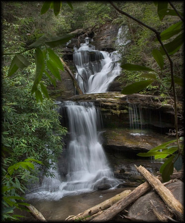
NE Georgia Waterfalls
|
The mountains of NE Georgia contain some of the most beautiful waterfalls in the United States. From small shoals to 30 ft drops, the NE Georgia Waterfalls allow you to relax with the sound of the rushing water and gaze at their surrounding beauty. These are some of the waterfalls in the area near Heaven's Landing: |
 Amicalola
Falls:
Amicalola
Falls:
Amicalola is a Cherokee word meaning
"tumbling waters." Located within Amicalola Falls State Park, these beautiful
falls slide and plunge 729 feet in seven cascades, making it the highest
waterfall in Georgia. At the base of the falls, there is a parking area, a
reflection pool, and .3-mile paved trail leading to an observation deck that
crosses the top of the falls.
Dawsonville/Dahlonega Area: The park's entrance is on GA Highway 52,
east of Ellijay or west of Dahlonega.
|
|
Anna Ruby
Falls:
Two creeks, Curtis and York, climax their
run down the steep slopes of Tray Mountain in twin waterfalls. Curtis Creek
falls 153 feet and York drops 50 feet. Although the .4-mile Anna Ruby Falls
Trail is paved, it is very steep. Benches are located along the trail for those
that want to sit and rest or just enjoy the scenic beauty of the area.
Helen/Hiawassee Area: Take GA 75 North from Helen for one mile. Turn
right on GA 356 for 1.5 miles, then go left on the entrance road to the falls.
|
DeSoto Falls:
There are five beautiful falls along the three-mile section of the DeSoto
Falls Trail located in the 650-acre recreation area. Three of these falls are
maintained for the hiker's viewing convenience, and are designated as the lower,
middle and upper DeSoto Falls. The lower falls cascade 20 feet. The middle,
and most scenic, drop 80 feet. Water from the upper falls rushes down a granite
rock incline for almost 200 feet and may be viewed from the flat, granite
formation which overlooks the falls.
Blairsville/Cleveland Area: From Cleveland, take U.S. 129 north 15 miles
to DeSoto Falls Recreation Area.
|
Dick's Creek
Falls:
This waterfall is about 60 feet high and makes a sheer drop over a granite
mound into the Chattooga River.
Clayton/Rabun County Area: From Clayton, drive east on Warwoman Road.
Turn right on Dick's Creek Road (or Sand Ford Road). Go .5-mile, then take a
left across the creek. Go 3.5 miles, cross the second ford and park at Bartram
Trail sign. Follow the trail north to Dick's Creek. Follow the creek to
viewing area at the top of the falls
Dukes Creek
Falls:
The Dukes Creek Trail, .8-miles in length, winds its way into Dukes Creek
Gorge where it dead ends across from the 300-foot Dukes Creek Falls. This area
also offers excellent gold panning opportunities.
Helen/Hiawassee Area: Take GA 75 north from Helen for 1.5 miles. Turn
left on GA 356 (Alternate 75) and go 2.3 miles to the Russell-Brasstown Scenic
Byway. Turn right and go two miles to the Dukes Creek Falls Recreation Area.
Helton Creek
Falls:
Helton Creek Falls Trail, .3-mile in length, follows Helton Creek to two
waterfalls. The trail accesses the lower falls at both the bottom and top of the
falls and ends at the bottom of the upper falls.
Blairsville/Cleveland Area: From Blairsville, take U.S. 129 south for 11
miles. Turn left on the first gravel road past the entrance to Vogel State Park.
Go 2.2 miles to a small pullout parking area. Trailhead will be on the right
High Shoals
Falls:
A succession of five waterfalls graces this 170-acre scenic area. These falls
have an estimated total vertical drop of 300 feet.
Helen/Hiawassee Area: Take GA 75 north from Helen for 11.4 miles. Turn
right on Forest Service Road 283 at the High Shoals sign. Go 1.5 miles on this
road to the High Shoals Scenic Area.
Horse Trough
Falls:
A succession of five waterfalls graces this 170-acre scenic area. These falls
have an estimated total vertical drop of 300 feet.
Helen/Hiawassee Area: Take GA 75 north from Helen for 11.4 miles. Turn
right on Forest Service Road 283 at the High Shoals sign. Go 1.5 miles on this
road to the High Shoals Scenic Area.
Martin Creek
Falls:
This two-tier waterfall is 35 feet high with aquatic plants covering the
weeping rock wall on the left. This 20-minute walk (.5 mile) follows the
Bartram Trail along the west side of the creek.
Clayton/Rabun County Area: From Clayton, go east on Warwoman Road for 3
miles. Turn left onto Forest Service Road 152, and drive past the Game Checking
Station. The park drive is .5-mile. Park in a small cleared camping area on
the left bend in the road. Walk west from the camping area. Cross Martin
Creek, then travel uphill for about .4 mile to the top of the falls.
Mill Creek
Falls:
The waterfall on Ground Hog Branch drops about 150 feet where it combines
with the main Mill Creek. The combined streams plunge another estimated 150
feet, ending in a series of rapids which cascade down the Mill Creek Gorge.
Helen/Hiawassee Area: From Hiawassee, take U.S. 76 east. Turn right on
GA Hwy. 75 and travel 3.5 miles. Turn left on Mill Creek Road (Forest Service
Road 26) for 2.5 miles. The road crosses Mill Creek 1.5 miles from pavement.
Park at the camping area on the right. Hike through the primitive camping area
and follow the west side of Mill Creek downstream.
Minnehaha
Falls:
The Minnehaha Trail, .4-mile in length, follows Fall Branch until it dead
ends at Minnehaha Falls. This waterfall is approximately 100 feet high (falling
and shoaling).
Clayton/Rabun County Area: Take U.S. 23/441 north from Tallulah Falls
for three miles to the Rabun Beach Recreation Area sign. Turn left onto Old
441. Go 2.5 miles and take a left on Lake Rabun Road. Go 1 mile past
Recreation area. Take a left on Low Gap Road. Follow Bear Gap road which forks
to the left. Go 1.5 miles to the sign marking the trail on the right side of
the road.
Mud Creek
Falls:
Also known as "Little Estatoah", the falls have vertical drop of 100 feet and
flow into Estatoah Falls in Dillard.
Clayton/Rabun County Area: Take Highway 441 north to Dillard. Turn
right on GA Highway 246 and follow signs to Sky Valley. At Sky Valley's
entrance gate, turn left. Turn right on Tahoe Road and follow to the falls.
For more waterfalls in the surrounding areas click here.
 Check Us Out On Facebook
here!!
Check Us Out On Facebook
here!!