.png)
A Mountain Estate Airpark....Like No Place On EARTH!
|
|


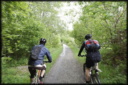
NE Georgia Biking
|
Northeast Georgia biking gives you the opportunity to take in all of the surrounding beauty in this area. When bicycling please remember the following tips and rules:
|
|
|
|
The following is a list of many trails located within a reasonable distance from Heaven's Landing: |
 Amicalola
Falls State Park (Dawsonville):
Amicalola
Falls State Park (Dawsonville):
Description: 16 miles of
singletrack that loops. Good for intermediate level. Extremely easy to get lost
so get a map.
Directions: Turn right out of driveway onto Hwy 441 S (13.8 miles). Turn
right towards GA-385 (0.1 miles). Turn left onto GA-385 (5.2 miles). GA-385
becomes GA-197 (0.1 miles). Turn left onto N Washington St/GA-197 (0.1 miles).
Turn right onto Monroe St./GA-115 (27.5 miles). Turn left onto Long Branch
Rd/GA-115 (4.7 miles). LONG BRANCH RD / GA-115 becomes US-19 S / GA-400 S (5.8
miles). Turn RIGHT onto GA-136 / GOLD CREEK HWY / AURARIA RD. Continue to follow
GA-136 (17.3 miles). Stay STRAIGHT to go onto GA-183 / ELLIOTT FAMILY PKWY (1.1
miles). Turn SLIGHT RIGHT onto GA-52 (1.5 miles). Turn LEFT onto HIGH SHOALS RD
(0.1 miles). Turn SLIGHT RIGHT onto SERVICE RD (.4 miles)
Contact: 240 Amicalola Falls State Park Rd, Dawsonville, GA 30534 - (706)
265-4703
Bull Mountain
Multi-User Trail (Dahlonega):
Suitable for hiking, bicycles
and horses
Description: This trail features a 4-mile single-track experience with 11
additional miles of lightly traveled dirt and gravel Forest Service roads to
complete the loop. Elevations range from 1700 to 2500 feet. The single-track
trail is shared by mountain bicycles and horses.
Contact: Toccoa Ranger District, Blue Ridge, GA - 706-632-3031
Directions: Take GA 52 west from Dahlonega for 8.5 miles to Grizzle store.
Turn right onto Nimblewill Road and continue for 2 miles. Turn right onto
Forest Service Road 28-I and follow signs for the Bull Mountain parking area on
Forest Service Road 83.
![]() Chicopee
Woods Trail System (Gainesville):
Chicopee
Woods Trail System (Gainesville):
Suitable for mountain
bicycles.
Description: 10 miles of 80% singletrack and 20% doubletrack trails. A well
maintained (by SORBA) example of what makes mountain biking so much fun. Lots of
great twisty rolling wooded single track with a few water crossings and some
easy riding sections. A great workout at the center on Zig Zag trail or a more
easy Outer Loop.
Contact: (770) 297-8319 - Call first for times, fees and directions
Directions: Go South on 441. Hwy 441 becomes 985. Take 985 to exit 4. Turn
right and follow signs to Elachee Nature Center.
Tallulah Gorge
State Park (Tallulah Falls):
Description: 11 miles of out
and back forest roads. The trail is a multi-use hiking and mountain biking
trail. Great scenery in the park.
Directions: Start from the Interpretive Center at Tallulah Gorge State Park
which is turning right at end of driveway to Tallulah Falls.
Contact: (706) 754-7981
Unicoi State
Park (Helen):
Description: 6 miles of
singletrack loop trails. Fast and neat trail with some switchbacks and berms.
Some tough climbs and nice scenery. Easy access and not too crowded!
Directions: Go to end of driveway and turn right at end of driveway and take Hwy
441 S. to Unicoi State Park exit (approx. 27 miles). Enter state park and go to
the front desk at the lodge and pay fee.
Contact: (706) 878-2201
![]() White
Twister (Clayton):
White
Twister (Clayton):
Description: 4 miles of
singletrack loop trails. From the main parking lot, backup 100 yards on the road
you came in on. Loop starts on the lower side of the road. Follow the trail and
you will cross ridges and realize the trail name is appropriate. Just before the
exit to the pay station, you will have some aggressive climbs. From the top of
the ridge you now go from the highest point on the trail to the lowest. Cross
the bridge, go through the ferns, along root ridge and down to the old railroad
bed. The last section travels an old railroad bed along Stonewall Creek. When
the trail intersect with US Forest Service Road 20, turn right and return to
the parking lot.
Directions: This trail is located in the Stonewall Falls Loop area. From
Clayton, travel South on Hwy 441/23/15 for 2.5 miles and turn right on the Tiger
Connector. Continue 1 mile and turn left at the 4-way stop. Go South on Hwy Old
441 for 2-1/2 miles and turn right onto US Forest Service Road 20. The parking
lot is 1.25 miles on US Forest Service Road 20.
![]() AG Center
Trail System (Gainesville):
AG Center
Trail System (Gainesville):
This trail is a race course rollercoaster. About 8 miles of fast, exciting singletrack. This trail demands your attention at all times. There are numerous log piles and mini ledges waiting to throw you. Enjoy the rock pile and big jump. Despite the obstacles, this trail has great flow. You can get into a great groove. There's one very challenging climb and at least two others that will get your attention. This trail was built by SORBA and they've done an incredible job. It is 8 miles of Singletrack and an advanced skill level is recommended. Take Hwy 441 S. turning right out of driveway. Hwy 441 S. becomes I-985. Take right to exit 20, turn left onto Hwy 60. Turn right at first light onto Calvary Church Rd. Go approx. 2 - 3 miles, past the Agriculture Center on your left, and look for a large grass parking lot on the left with white fencing.
Bull Mountain
Trail (Dahlonega):
This is an 11-mile Singletrack & fire road Trail for Intermediate skill level. This is a 1.8 miles to the trailhead. There is a three mile climb at the start (all Singletrack). Many small streams crossings, technical downhills, rocky climbs. To make a longer loop, take Bare Hare Trail (will join back with bull mountain trail). From Dahlonega, take GA52 West. Turn right on Nimblewill Church Rd. Proceed three to four miles. Next, turn right on FS 28 (gravel road) continue on this for .4 miles. Make your first left on FS 83. For more info, contact Toccoa Ranger District at (706) 745-6928
![]() Chicopee
Woods Trail System (Gainesville):
Chicopee
Woods Trail System (Gainesville):
This 19-mile trail is an excellent singletrack with some technical sections and some fast sections, but it is not very well marked though. Intermediate skill level recommended. Take 441 S. turning right out of driveway. Hwy 441 S. becomes I-985. Take I-985 to exit 4 , go right, and follow signs to Elachee Nature Center, you will see signs for parking area, you drive past a few golf course holes. Closed when raining.
![]() Davenport
Mountain (Blairsville):
Davenport
Mountain (Blairsville):
This trail loops around Davenport Mountain with some moderate grades, and offers views of Nottely Lake. This trail is recommended for riders accustomed to riding on flat to rolling terrain, young, or inexperienced riders. Cross country riding is not allowed and riders must stay on the trail. This five miles trail is suitable for ATV's and motorcycles and mountain bicycles. Turn left out of driveway onto Hwy 441 and go North. At 3rd traffic light turn left. At next light go straight. This is 76W. Beginning at the traffic light at the intersection of U.S. 76/APD Hwy 515 and U.S. 19/129, go west on U.S. 76/APD Hwy 515 for 7.0 miles. Turn right onto GA 325 and go 2.3 miles to the STOP sign. Turn left, still on GA 325, and go 2.5 miles until you see a Christmas tree farm on the right. Go another 0.3 miles and turn right onto Davenport Mountain Road. At the foot of the hill, turn right onto Forest Service Road #143. Follow the gravel road 1.1 miles to the parking lot on your right. The ATV trail begins at the back end of the parking lot.
![]() Dawson
Forest (Dawsonville):
Dawson
Forest (Dawsonville):
There are three separate trails on the property. Two are around 7 miles long and one (the blue trail- my favorite) is around 13 miles. These trails are well marked, and will provide a good Aerobic workout. Trails are shared by horses, but are good shape. Does get muddy after rains. $5 daily use fee or $50 annual pass. Please respect the rights of other users, Horses can become spooked, but talking to them as you approach helps. There are 27 miles of trails which are Singletrack and Fire Roads. Advanced skill level recommended. Take Ga 400 north out of Atlanta.. Just above Cumming Ga the road will no longer be limited access, but start having intersections and a few red lights. Continue North on 400 6.4 miles past the 1st red light. Make a left on Dawson Forest Road.( just before you get to North Georgia Premium Outlet Mall) Continue on Dawson Forest Road 5.5 Miles. You will Pass a gate and the parking is 100 yards on the right.
![]() Gainesville
College Trails (Oakwood):
Gainesville
College Trails (Oakwood):
The Gainesville College trail is a Singletrack loop. It is a fun, little trail (about 3.5 miles in and out of the woods) with lots of twists and turns. The best way to take this trail, and the more challenging way, is to start at the bottom by the pond. If you start this way, then most of the trail is uphill (if you can call it that). A great place to introduce someone to MTB. The trail can be muddy at times. It is a Singletrack and is great for beginners. Turn right out of driveway onto Hwy 441S. Hwy 441 S becomes I-985. Travel south on I-985 until you get to exit 16 which is Oakwood. Get off on that exit and then take a right. At the third light you will see Gainesville College on the right. I recommend entering the college at the first right after the light. Take a right into the college here and drive past the tennis courts and the first building on the left. After the building on the left, take a left into the parking lot. This is where you park, and the trails are towards the woods and building at the end of the driveway.
![]() GMA Trails
(Cumming):
GMA Trails
(Cumming):
From Atlanta, take GA 400 (US 19) north towards Cumming. Take exit 9, GA 141, to the right. Shortly after exiting right, take the first left just before the Waffle House. Continue on this road until it intersects another road at a "T" intersection. Turn right. Continue on this road for approximately 2 miles. Turn left onto Trammell. Continue on Trammell until it becomes a dirt road. GMA entrance on the right.
Hickory Nut
Trail (Helen):
This trail is 19. miles long with 2500 feet of climbing. Trail type is Singletrack and Fire Roads. Advance skill level recommended. From Bridge in downtown Helen, go west on GA 75 for 1.1 miles, then turn right on GA 356. Go .1 mile and turn left. Park at bike shop.
Hickory Nut
Trail Loop (Helen):
This is a 7+ mile loop, most formerly jeep trail, which has grown back almost to Singletrack status, bridged creek crossings (no wet feet). It is Singletrack and Fire Roads and Intermediate skill level is recommended. Take Chattahoochie st. NE from downtown, look for signboard on left less than 1/4 mile from downtown. Follow red blazes on trees.
Jake
Mountain (Dahlonega):
This trail is 7.6 miles in length and is a loop with extension. It is a combination of Singletrack and Fire Roads. Intermediate skill level recommended. Take highway 400 to Highway 60 north to Dahlonega. At KFC, turn left onto 52 W. Follow 52 west to Nimblewill. Turn right onto Nimblewill Road 1.8 miles. Jake Mountain Parking is on the right.
![]() Jones Creek
Ridge Trail (Dahlonega):
Jones Creek
Ridge Trail (Dahlonega):
This trail features a moderate 5.9 mile single-track experience connecting the Bull Mountain Trail system with the Turner Creek Trail system with a beautiful view of the Soil Conservation Service flood control dam and its immediate environs. Elevations range from 1600 feet at the dam to 2320 feet at the ridge top. This trail is shared by bicyclists, equestrians, hunters and hikers. USGS map Nimblewill Quad. From the parking area on FS 82, continue north on FS 83 to where the trail turns right at the trail marker sign directly across from the entry onto the Bull Mountain Trail. Ahead is a gated road going east. Follow this level road to the Soil Conservation Dam. Cross dam and begin ascent to the ridge above Jones Creek. Follow trail past several wildlife food plots and along the wooded ridge. After the last food plot, descend along graded trail to FS Road 77A where it intersects FS Road 77. Cross FS Road 77 and go about 50 feet north and turn right onto Turner Creek Connector. USE EXTREME CAUTION AT THIS CROSSING! Follow connector south and east to Turner Creek Trial in about ¼ mile. For more info, contact Toccoa Ranger District at (706) 745-6928
![]() Lady
Slipper Look at Lake Russell (Cornelia):
Lady
Slipper Look at Lake Russell (Cornelia):
This trail is a seven mile loop of Singletrack and Fire Roads. Intermediate skill level recommended. Mostly Singletrack with a one steep climb and a couple of fast descents. Trail needs some work to improve drainage; ruts in trail at some points, but downhills are pretty safe, with one tricky "butt on wheel" section. It is located within the Lake Russell Recreation Complex on the Chattahoochee Natl. Forest. Near mile marker 48, take exit for GA 197. At the end of the exit turn right. Go past Habersham Central High School, through 4 way stop, then another 2 miles to stop sign. BP convenience store will be on your left. Turn right and go approx 3/4 mile. Just past the railroad bridge, turn left into Lake Russell recreation area. Go 2 miles to bottom of hill, take first left, pay fee, and park. To trailhead, take gated road around left side of Nancytown Lake. Take first right and go to end of parking area. Trailhead is here. . For more info, contact the Chattooga Ranger District 706-754-6221.
![]() Lake
Russell WMA (Cornelia):
Lake
Russell WMA (Cornelia):
This is one of the states
largest Wildlife Management Areas. Do not confuse this WMA with Lake Russell,
the reservoir of the same name on the Savannah River. This maze of gravel
roads, logging roads, and Singletrack (mostly horse) trails are enough to keep a
mountain biker happy for days. While not having the dramatic elevation changes
of the mountains further north, the undulating terrain is still quite rugged and
challenging. Anyone not familiar with this area is advised to have a good map
and navigation skills, as all roads and trails are not marked, nor are they on
most available maps! Some parts of this area have been extensively logged, so
many new roads have been cut recently, while others that were once open to
traffic, are now gated.
Be aware that this area is quite popular for equestrians, so remember to be
courteous. And, as with all state WMA's, avoid this area during managed deer
hunts! Directions: Turn Right out of driveway onto Hwy 441 S. Turn right onto
GA-197. Turn left onto US-123 toward Mt. Airy, and look for the signs for Lake
Russell Recreation Area and turn left.
Most trails and roads are easily accessible from the parking area located at the
dam on Nancytown Lake. There is now a $3 parking fee for vehicles in the main
recreation area.
|
Oakey Mountain
Trail: 6.2 miles
To north parking lot: From Clayton, go west on U.S. 76 for 6.8 miles. Turn left on Charlie Mountain Road and proceed until it dead ends. Turn right on Bridge Creek Road and go 2 miles, where the road dead ends at Lake Burton Dam Road. Turn right and drive 1.6 miles to the entrance road on the left.
To south parking lot: From Clayton, go west on U.S. 76 for 6.8 miles. Turn left on Charlie Mountain Road and proceed until it dead ends. Turn right on Bridge Creek Road and go 2 miles, where it dead ends at Lake Burton Dam Road. Turn left and drive 4.4 miles to Flat Creek Road. Turn right, below Seed Lake Dam, and go 2.1 miles until the pavement ends. Continue on the gravel road for 0.8 mile to the entrance road on the right.
Popcorn Creek
Trail: 15 Miles
Located 11.0 miles west of Clayton at the intersection of US 76 and GA 197
Sandy Ford
Trail (Clayton):
This trail is 7.75 miles and rated as strenuous. Drive 6.0 miles east of Clayton on War Woman Road and turn right onto Sandy Ford Road. Park near the creek 2.25 miles away.
![]() Stonewall
Falls Loop (Tiger):
Stonewall
Falls Loop (Tiger):
This trail is an 8-mile loop,
rated moderately difficult and take an average of two and half hours to
complete. The elevation change varies from 1,875 feet to 2,380 feet. Start
from the parkinglot and ascend forest service road for approximately two and
one-half mile to the lookout point on Saga Mountain. From here the trail begins
to narrow and ascends and descends around Crunkleton Ridge. From Crunkleton
Ridge the trails start and descends.
Bikers may choose difficulty paths Singletrack. At approximately mile 5, the
trail descends ? the Stonewall creek. Upon nearing the creek, continue easy
biking for the next two and one-half miles while crossing the creek four times
to the Stonewall Creek Waterfalls. From the waterfalls, turn left onto the old
? road and continue the loop for another one-quarters mile back to the parking
area. For more info, contact the Tallulah Ranger District 706-782-3320.
![]() Stoneplace
Trail (Tallulah Falls):
Stoneplace
Trail (Tallulah Falls):
This trail is 10 miles in length and is for intermediate skill level riders. The trail is all fire road from the top of Tallulah Gorge to Lake Tugalo. The trail is 90% downhill on the way in; so you you do the math on the way out! At Tallulah Gorge State Park, go to the Jane Hurt Yarn Interpretive Center and get a permit for the ride (it’s free). They will show you to the trailhead from here.
![]() Turner
Creek Trail (Dahlonega):
Turner
Creek Trail (Dahlonega):
This trail features a moderate 1.7 mile single-track experience with approximately 6 miles of lightly traveled dirt and gravel forest roads to complete the loop. Elevations range from 1650 feet at FS 29-1 to 1800 feet at the north end of Turner Creek Trail (FS 280A). The Singletrack trail is shared by mountain bikers and horses. The remaining 6 miles is subject to motor vehicle traffic. For more info, contact Toccoa Ranger District at 706-745-6928.
Upper
Chattahoochee Loop (Helen):
This trail offers over 20 miles of Mountain Bike, hiker, and horse trails. This area is just north of Helen on the Chattahoochee Natl. Forest. For more info, contact the Chattooga Ranger District 706-754-6221.
![]() White
Twister Loop (Tiger):
White
Twister Loop (Tiger):
This four mile Singletrack trail is located in the Stonewall Falls Loop area. From Clayton, travel South on Hwy 441/23/15 for 2.5 miles and turn right on the Tiger Connector. Continue 1 mile and turn left at the 4-way stop. Go South on Hwy Old 441 for 2-1/2 miles and turn right onto USFS Road #20. The parking lot is 1.25 miles on USFS Road #20. From the main parking lot, backup 100 yards on the road you came in on. The White Twister loop starts on the lower side of the road. Follow the trail and you will cross ridges and realize the trail name is appropriate. Just before the exit to the pay station, you will have some aggressive climbs. From the top of the ridge you now go from the highest point on the trail to the lowest. Cross the bridge, go through the ferns, along root ridge and down to the old railroad bed. The last section travels an old railroad bed along Stonewall Creek. When the trail intersect with USFS Road #20, turn right and return to the parking lot. For more info, contact the Tallulah Ranger District 706-782-3320.
|
